
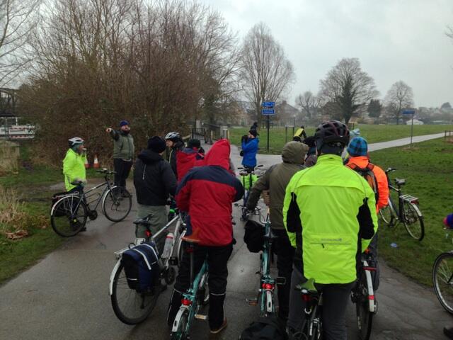
 I went on a ‘Cycling Infrastructure Safari’ around Cambridge yesterday hosted by the Cambridge Cycling Campaign. There was an interesting mix of cycle campaigners and bloggers from across East Anglia and London there. It was an interesting day despite the bitter cold and snow.
During the ride around the highlights of Cambridge’s cycling infrastructure I kept having the same thought, why are we avoiding the main roads? We went right around Cambridge from the Station to Milton Country Park, the William B Gates Building and through the city centre, 17 miles in all, yet only perhaps 1/2 a mile of that was on main roads. It showed that the Cambridge Cycling Campaign have been very successful in opening up this secondary network of routes, using side streets, cut-throughs, the riverside and so on. It would not be possible to circumnavigate Ely on such a secondary network. I can’t argue that Cambridge has a well developed secondary network, but as they admitted at the end, their main roads are as undeveloped as anywhere else in the UK.
This is important because:
- Even a good secondary network can only get modal share to a certain point.
- I am not sure the secondary network approach is transferable to other places (inc. Ely and East Cambs).
Limits of a secondary network
As highlighted quite well here a secondary network has certain flaws.
Firstly it’s not a single network it’s a patchwork of smaller networks sliced up by the main roads. Crossing these main roads becomes an issue in it’s own right. This was nicely highlighted a couple of times yesterday. We were shown a few innovative crossing points, which were great but kind of missed the point. They were like a scaffold that allowed you to get over the elephant in the the room.
 In some cases these crossing points required you to “approach them correctly”. This phrase was actually used at one point when a group of us, being led by one of the locals, went ‘the wrong way’ and didn’t come up to the wide toucan crossing on Newmarket Road we were going to see. In this case ‘the wrong way’ was going straight along Sturton Street and Occupation Road rather than taking the not very obvious right turn into Abbey Walk.
This highlights the second issue with a secondary network. The routes are not the direct, obvious ones. These direct obvious routes are the main roads, which only became the main roads because they are the best routes to the important places. Routes on a secondary network are out of the way, circuitous and require local knowledge to navigate them. To use them well you have to be like a London cabbie and learn ‘the knowledge’. This is a big hurdle to increasing modal share.
Note: Cambridge Cycling Campaign are attempting to get the road space re-allocated in the Occupation Road area mentioned above, see letter and comments below.
Is the Cambridge Model transferable?
My other thought while riding around yesterday was would this work in Ely and if not, why not?
 I came to the conclusion that Cambridge has a special feature that most places do not, the commons. These are several large green swathes of common land that extend virtually to the centre of the city. There a string of them along the river which allows for a huge amount of secondary network provision. A fair proportion of the route yesterday was along the river. Far more than on the main roads. It was (or would have been without the driving snow) very pleasant. This space has been exploited very well to give some useful routes.
However, most places, including Ely, do not have this kind of useful space. In most places this land has been built on and in-filled. Without it I doubt it’s possible for most places to get a secondary network that is as developed as Cambridge’s. It’s certainly hard to see how you would achieve one in Ely and the surrounding area.
Is it the right approach?
Should the UK be “going Cambridge” and following the approach of our premier cycling city. It seems to us that the answer is no.
It feels like Cambridge has got as far as it can with it’s secondary network, they have increased modal share but these extra cyclists spill out onto the main roads where the infrastructure is almost totally lacking. This ends in the same familiar conflicts which happen across the UK. Motorists in conflict with the cyclists who brave the road and pedestrians in conflict with the cyclists who use the pavements to avoid the busy traffic.
The Cambridge approach sidesteps the difficult issue of re-allocating space on the carriageway. That’s campaign-speak for taking road space away from cars and giving it to bikes. It’s politically hugely contentious, but it’s the unavoidable task if we’re to get world class cycling infrastructure in the UK.
Here at the Ely Cycling Campaign we have decided to campaign for a complete network, not just a secondary one. We don’t want to spend time, effort and resources getting to where Cambridge is now. We want to tackle the big issue of re-allocating road space head-on. We don’t want to take the side street and cut-through route to getting cycling infrastructure we want to use the main roads, metaphorically and literally.
For more information on our approach see our strategy.

Fair comment. I think what was shown of the major roads (Newmarket Road, Elizabeth Way, Milton Road, Mill Road, Histon Road, Madingley Road, Gonville Place, Cherry Hinton Road, Hills Road- most of these were simply crossed!) showed how poor they were, and there was some explanation from Martin, Jim etc on how difficult it is to get the county to do anything there.
I think it would be good if we were to band together and all ask for the same thing, so that’s it’s not individual campaigns fighting their individual battles but all of us asking for the same thing, re-allocation of space.
You oddly seem to be implying that Cambridge Cycling Campaign isn’t campaigning to fix the main roads or that leaving these untreated is in some way considered acceptable.
To take a few recent articles, whose locations we deliberately went via:
Vision 2016: Corridor Improvements: http://www.camcycle.org.uk/vision2016/corridors.html
Vision 2016: Junction Improvements: http://www.camcycle.org.uk/vision2016/junctions.html
Newnham to Newmarket Road supercycleway: http://www.camcycle.org.uk/newsletters/103/article4.html
Catholic Church junction: http://www.camcycle.org.uk/newsletters/106/article3.html
Cambridge Local Plan: http://www.camcycle.org.uk/newsletters/104/article8.html
Mill Road traffic calming: http://www.camcycle.org.uk/newsletters/86/article4.html
Gilbert Road: http://www.camcycle.org.uk/campaigning/issues/gilbertroad/
Eastern Gate: http://www.camcycle.org.uk/newsletters/97/article8.html
There was no ‘admit’ about this – it was made quite clear yesterday that this is the area that much work by the County Council is needed if modal share is to rise, and which, moreover, the government needs to fund.
I don’t think Andy is implying anything on your campaigning (at least I didn’t read it that way), but he was only commenting on the current state of cycling facilities in Cambridge, which on the whole aren’t much better than anywhere else.
He’s quite right that we can’t really create a secondary network in Ely except perhaps in the residential areas in the north and west which are similar to the Mill Road area where the secondary network works reasonably well.
Without reallocating some space on the main routes you can’t really get anywhere useful in Ely (i.e. the centre/station) whereas in Cambridge you can use the river, parks and back streets and they don’t create a huge detour. For Ely it’ll mean taking some parking spaces (Lynn Road), making roads one way for cars (Back Hill, Broad Street, Station Road) or blocking roads off for through traffic (Church Lane, Chapel Street) and we do want to campaign for those things to happen. I’ve only read a few of your links and for example on your Histon Road proposal you seem to be shying away from taking parking spaces on the southern end where it narrows or you also support that it doesn’t become 20mph. This is not something we would support, we don’t want to compromise on the important parts but maybe we are still new and optimistic 🙂
For us as Ely Cycling Campaign I think it simply means that we should focus on getting something done on the main routes and as there are quite a few developments happening (i.e. there will be some money) we have quite a good chance of getting some of it done…. hopefully…
Andy and mg are both right about the problems cycling faces in Ely. I’d suggest Ely is facing the sort of problems that an expanding Cambridge was probably experiencing in the 1930’s, before restraints on traffic through the medieval centre were introduced, though even then the Cambridge scale, and the opportunities to bypass the centre, were larger than in Ely today. One suspects that quite a high proportion of traffic in the centre of Ely is passing through, without business in the centre itself. This is common in many towns and cities.
To approach the centre (or the station) by bike, from all quarters of Ely, even if you can begin your journey on traffic-free routes or quiet roads you are forced back onto the old main streets because lines of severance abound between these radial streets, produced by the back gardens of successive developments. It’s simply the way the city grew.
The funding to accommodate cycles safely on the main streets will have to come largely from the major developments currently proceeding and proposed, and which are generating ever more motor traffic which is compounding the difficulties faced by cycling and walking and compromising the attractiveness of a very small historic and riverside area.
The planning and highway authorities do accept the “road user hierarchy”, which gives priority to walking and cycling, in their policy frameworks but are timid in its application. (See it in LTN 2/08 and elsewhere.) It would seem that to make and keep Ely as a place for people (not motor vehicles) the authorities need to be persuaded to apply the hierarchy, to accept that strong motor traffic restraint is necessary in the central areas, in the face of a rapidly growing population, and to take more roadspace so that walking and cycling become modes of preference. The alternative is likely to be growing gridlock, pollution and collision risk.
One way which has worked in other European countries is to segment the historic core, allowing only walking, cycling, perhaps buses, and emergency access to pass between the segments, ie a specific form of “selective permeability”. Thus one can reach the centre by motor vehicle, but only leave it again by the same route. The next stage must be to progressively move the car parking further from the centre.
I suggest the main task of the Ely Campaign could be to move council and public opinion to accept that growth of the city (and of Littleport nearby) is incompatible with unfettered motor access, and to get the planners and highway experts to work together to design a growing city’s streets for people.
Readers might find it useful if, next to your sentence about Occupation Road, you add a link to our letter which specifically argues for roadspace reallocation:
Click to access C11013EasternGateConsultation.pdf
The ‘local’ you mention was in fact busy explaining to Mark about how the City Council in fact intends to fill in the roundabout, add 2m cycle lanes (which were going to be 1.5m until we campaigned), and restore the historical link from Occupation Road to Abbey Walk. The adopted proposals show all this:
Click to access eastern-gate-spd.pdf
(warning.. 32MB PDF!)
Added an extra sentence with a link to clarify the situation